Want to know how jammed the streets in Jakarta? Now be known through the Google Maps service. Yes, the internet giant from the United States is already extending its expansion into the traffic in Jakarta. To try it, users can be visited http://maps.google.co.id. Then activate the layer 'Traffic' that its icon can be found at the top right of the display Google Maps. The color is adjusted to cover road traffic speed relative to road speed limit. Green means traffic moves fast and red or black means the traffic moving slowly or not moving at all.
Google Maps Jakarta Offer Traffic Information
Want to know how jammed the streets in Jakarta? Now be known through the Google Maps service. Yes, the internet giant from the United States is already extending its expansion into the traffic in Jakarta. To try it, users can be visited http://maps.google.co.id. Then activate the layer 'Traffic' that its icon can be found at the top right of the display Google Maps. The color is adjusted to cover road traffic speed relative to road speed limit. Green means traffic moves fast and red or black means the traffic moving slowly or not moving at all.
5.5 magnitude quake hits Sumatra Tarutung
After overnight hit Tahuna, North Sulawesi, this morning earthquake shook parts of Indonesia back precisely in the area Tarutung, North Sumatra. An earthquake measuring 5.5 on the Richter Scale occurred at a depth of 10 kilometers and stated no tsunami potential.
Based on data released sites Climatology Meteorology and Geophysics Agency (BMKG), Tuesday (06/14/2011), the quake occurred at 7:08 pm.
The quake's epicenter was recorded at 30 km southeast of Tarutung, North Sumatra and 39 km northeast of Sibolga, North Sumatra. The location coordinates of the earthquake was recorded at 1.79 N and 99.13 latitude.
Know Your Puzzle-GIS: GIS Software Free Java-Based
Java Puzzle-GIS is Geographic Information Systems (GIS) development platform that is built using the NetBeans Platform. The main purpose built Puzzle-GIS is the availability of free GIS software that can produce spatial data as well as a competitive tool as an alternative to other commercial GIS software.

How the iPhone Knowing your location?
Allegations that the iPhone / iPad has been tracking and recording the location-based data on mobile devices has been argued by Apple. Bitten apple logo company stated that it was just a bug that occurs in a location-based software that has been storing the user's location without ever automatically delete it after so long. Then how exactly the iPhone know your location?

Working with Garmin Data Cards
You have the option to transfer all data types in MapSource to a removable storage card. The storage card accepts all data types, but only some Garmin GPS devices are capable of reading all data types. All Garmin GPS devices, however, are capable of reading the map data.
The following are possible scenarios when transferring MapSource data. NOTE: Not all data transfer options will be available in MapSource unless you own the specific GPS device:
Transferring and Saving MapSource Data For GPS GARMIN
Map Sets, waypoints, routes, and tracks can be transferred from MapSource to a Garmin device or from a Garmin device to MapSource.
NOTE: For information on connecting your GPS or other Garmin device to your computer, refer to your unit's Owner's Manual. Always check your GPS Owner's Manual to verify which data transfer options are available.
Data can be transferred in a variety of methods, as shown in the list below:
- To the internal memory of a Garmin GPS device, which accepts all data types: maps, waypoints, routes, and tracks. You can transfer through a Serial Port or a USB Port (if applicable).
- To a Storage Card in a Garmin GPS Device via a serial or USB port (if applicable). The storage card accepts all data types, but only some Garmin GPS devices are capable of reading all data types.
- To a Garmin storage card in a Garmin USB data card programmer. Some GPS devices will accept all data types, but most only accept map data.
- To a non-Garmin storage card in a Card Reader connected to your computer. Depending on what your Garmin GPS Device supports, the available card types are Compact Flash (CF) or Secure Digital (SD) Cards. Only map data may be transferred.
- To a Secure Digital (SD) Card in a Garmin iQue or to the unit’s internal memory. Only maps may be transferred from MapSource to the iQue. Maps are saved and transferred to the iQue during the next HotSync operation. iQue users may also transfer tracks from the iQue to MapSource via a HotSync operation.
- To a Secure Digital (SD) Card or to a Garmin cf Que in a Pocket PC, or to the unit's internal memory. You can transfer maps, waypoints, and tracks; route transfer is not supported at this time.
DATA CONVERSION INTO SHP PostGIS FOR USE IN
Observe the sql file, whose contents would make the table and its content in accordance with shp files. example sql file content (road.sql): BEGIN; CREATE TABLE "troad" (gid serial PRIMARY KEY, "Fnode_" int8, "Tnode_" int8, "Lpoly_" int8, "Rpoly_" int8, "Length" float8, "Road_" int8, "Road_id" int8, "F_code" int2, "Name_e" varchar (26), "Name_f" varchar (26)); SELECT AddGeometryColumn troad ('',' ',' the_geom ',' -1 ',' MULTILINESTRING ', 2); INSERT INTO "troad" ("fnode_", "tnode_", "lpoly_", "rpoly_", "length", "road_", "road_id", "f_code", "name_e", "name_f", the_geom) VALUES ('65 ', '70', '3 ', '3', '31779 .260 ', '1', '1 ', '74', NULL, NULL, '01050000000100000001020000000400000000000000164F414100000060EB773
OVERVIEW OF INSTALLATION PostgreSQL and PostGIS
MAINTAINING CONSISTENCY IN COLUMN SPATIAL DATA Make sure we meet the geometry column OpenGIS standard specification. One of them with the function IsValid (). For example: select IsValid ('LINESTRING (0 0, 1 1)'), IsValid ('LINESTRING (0 0.0 0)'); IsValid | IsValid ---------+--------- t | f There are ways to make us keep the data in order to remain compliant, ie by creating a check constraint. For example: ALTER TABLE mytable ADD CONSTRAINT CHECK geometry_valid_check (IsValid (the_geom)); check constraint will also be created automatically if you add a column geometric with AddGeometryColumn command (). LOADING spatial data There are several methods we can use. The first way is to use insert query command as usual. Suppose we create a file (roads.sql) containing:
HOW TO MAP SERVER INSTALLATION IN Chameleon
INSTALLATION MS4W, MAPLAB AND Chameleon MS4W MS4W can be downloaded at www.maptools.org. In it are united application Apache Web Server, PHP, Map Server and the various libraries required to construct WebGIS system. There are two versions that can be downloaded MS4W, version 1.x and 2.x versions. But if we want to use Chameleon framework, more either select MS4W version 1.x (in use today is version 1.6) because the Chameleon not yet completely support PHP5 on version 2.x MS4W package. After you successfully download ms4w_1.6.zip, then extract the contents into root of the hard disk partition (eg C: / or D: /), so that the entire contents of the package is located in
MapServer WebGIS CREATING DEMO APPLICATION
MapServer WebGIS CREATING DEMO APPLICATION
For more convenience, we will use GIS-based Web application demo MapServer and Chameleon framework that can be downloaded at http://www.hatma.info/download/gis/Demo_MapServer.zip. After the download is complete, extract its contents into the appropriate directory, ie: apps, http.d and Apache / htdocs, the directory ms4w you. Then restart Apache by executing apache-restart.bat. Open http://localhost with a web browser, then click the demo link on the "Hatma Suryotrisongko Web GIS Demo URLs: "(http://localhost/demo/demo.phtml) Link URL demo program, on the main page Display Web GIS Demo www.hatma.info 1 WebgGIS with MapServer - MapLab - Chameleon - PostGIS
POSITION TRACKING SYSTEM USING GPS CAR VIA SMS
This system is used for
Track position and view tracking vehicles on a region map. System
designed is a software that can make requests to the position
particular vehicle and processing the response data into the vehicle's position in a
area map., as well as hardware which connect with a GPS receiver to
receive requests and respond position via SMS.
QUICK USING AUTOCAD MAP
AUTOCAD MAP A. About AutoCAD AutoCAD is one of the images with computer-assisted design is quite sophisticated. Slowly but surely
experienced AutoCAD drawing automation, replacing manual functions that had been dominating the
work in all fields. High compatibility allows images - AutoCAD drawings can be accepted by most other
drawing programs and can be printed using almost any printing equipment. AutoCAD has a fairly
complete facilities to create an image - the image of two-dimensional and three dimensional.
Some reasons for using AutoCAD from the manual way to produce the image:
MAKE A MAP OF USING GOOGLE EARTH
How to make a map using Google Earth as a base map.
Step tops are made:
1. Open google earth and find the location that will be done
mapping.
2. After the image search google earth appears, select the menu line for
make digitized maps, digitized maps created in accordance image
which is on google earth, when using the line points
not until the beginning of line digitization met with the finish line
digitization, because when the meeting will be shaped polygon.
CUT IMAGE WITH ERRMAPPER
III. IMAGE PROCESSING A. Enabling Courses ER Mapper
o From the Windows 95 or Windows 98 or Windows other non-switch / close all other programs (if any)
and disable the screen saver program (if any).
and disable the screen saver program (if any).
o From the Start menu select Programs and then select ER Mapper - ER Mapper will display the image as
o Or from desktop computers to look for the shortcut icon like picture below, then click two times, so also
will show the menu as above.software used. Data conversion is the conversion of one data format into
o Or from desktop computers to look for the shortcut icon like picture below, then click two times, so also
will show the menu as above.software used. Data conversion is the conversion of one data format into
another format, this can be done by doing the import and export data. Data on import and export there
are 2 types of raster data and
DETERMINING coordinate KARTISIUS
Previously, you have determined the coordinates of the location of objects and places. Now, you're learning how to determine the position of points on the Cartesian coordinate system. Come on, consider the following picture.The picture is called Cartesian coordinates. Cartesian coordinate system consists of a horizontal axis (x-axis) and vertical axis (y-axis). The second axis function is to determine the position of a point. The points on a Cartesian coordinate point pairs on the x-axis and y-axis (x, y). Where X is called abscissa and y is called ordinate. Intersect
between the x-axis and y-axis at point 0 (zero) is called the center coordinates. Based on the Cartesian coordinate system that you can obtain the following information.
between the x-axis and y-axis at point 0 (zero) is called the center coordinates. Based on the Cartesian coordinate system that you can obtain the following information.
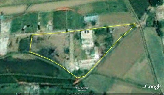
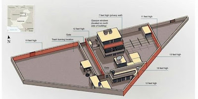
The location of Osama Bin Laden's Mansion in Google Earth
The shooting Osama Bin Laden has become headline news around the world. Osama was reported shot in a mansion, stately building in Abbottabad, a city that is relatively quiet and cool in northern Pakistan. You can view the location of Osama Bin Laden's mansion in Google Earth by downloading this KML file.
 |
Classification Lindgren
Lindgren (1907, 1913 and 1922) popularized the Genetic Classification or deposit of product classification mechanics or chemical concentration and classification of hydrothermal veins (hydrothermal vein). In group Lindgren including pirometa-somatic (igneous metamorpik) and hydrothermal deposits.
Classification Lindgren (Modification)
1. The precipitate that formed through a process of chemical concentrations (Temperature and Pressure Varies)
How to Use a Garmin GPSMAP 60CSx
Garmin GPSMAP 60 CSX is a tool most widely used in Indonesia because of the level of accuracy in determining the position with a tolerance of between 5 to 15 meters (assuming a gain of more than 3 satellite signals). The use of the Garmin GPSMAP 60 CSX very easy, because it already comes with a few navigation buttons and menu options quickly. Types of GPS can also be used for various purposes such as for surveys, find out the sunrise and sunset, predicts the number of fish in one location, know the circulation of the moon and sun, and others.Function keys Garmin GPSMAP 60 CSX:1. The "IN" and "OUT"a. In Map view: used to zoom in and out of the map (Zoom in and zoom out).b. At Compass Views: used to change the course scale pointerc. On Display Altimeter: used to zoom in and zoom out history / changes in altitude or air pressure.2. Button "PAGE"Used to move to move to several major applications of GPS. By default, when the first ignition, the GPS will display satellite images. After the page button is pressed, it will move to the next screen suitable arrangement, such as compass, altimeter, the main menu (main menu), or the trip computer3. Button "MENU"Menu button has several functions:a. If pressed 1 times, it will display the menu options on the application being performed.b. If pressed 2 times, it will display the main menu.4. The "ENTR"Used to approve the choice or request given by the GPS.5. Button "QUIT"Used to cancel a choice or request given by the GPS. If pressed when not given the option (in the form of "yes and no" or "ok"), then pressing this button will be inversely proportional to the page (switch to several applications in the opposite)6. The "FIND"Used to find something that aa in the vicinity. When the "FIND" button is pressed, it will be raised several options, such as waypoints, geocache, cities, All Point of Interest, and others.7. Button "MARK"Used to indicate on a map where the GPS is located. This sign can be used as an initial benchmark measurement or as a marker coordinates.8. Button the right, left, up and down (Rocker button)Used to select the available options and to enter data or the pointing map.9. Button "POWER"Press and hold Used to turn on or turn off the GPS. Press then release to set the backlight (the light on the GPS)How to Use the Garmin GPSMAP 60CSx 2This he continued from part 1 in the article "How to Use the Garmin GPSMAP 60CSx" please read it goes ... ...The following menus will be explained on the GPS and its functions.1. Menu "Satellite"When first turned on, GPS will display the satellite menu. Where in this menu are shown in the status of satellite reception. To get a good satellite signal (large signal strength) then the GPS must be outside with no obstructions to the sky, and sunny weather. or it could be by adding an external antenna that plugs into your GPS device. Make sure that the GPS acquire a minimum of 3 satellite signals, the status of this acceptance can be seen on the bar below the circle the satellite. Satellite signals that can be used that is the bar that contains, not a white bar.After the signal obtained is sufficient, then at the top of the screen will show us the coordinates of latitude and longitude position and the position tolerance shown by the "location". If the location shows the ± 10m, meaning the GPS to predict the location we are in a radius of 10 meters from the coordinate position indicated by GPS.In the center, there are two circles that large and small circles. The second circle represents the sky. Small circle mean radius of our vision to the sky by 45 °. Large circle, representing our vision into the sky at 180 degrees. Satellite image with respective numbers scattered around the large and small circle represents the satellite position at that time.2. Menu "MAP (Map)"When selecting this menu, will appear on the map as if we look at a map in general. The difference is that there is a black triangle in the middle of the map is displayed. This triangle shows the position we are on the surface of the earth and the GPS directions. On the menu map, we can measure the distance of a point with another point by pressing the Rokr. We can also see the direction of navigation when searching a site.3. Menu "Trip Computer"In this menu, there are the numbers to know: Trip Odom, max speed, moving time, moving avg, stopped, averall avg, elevation, odometer. The function above can search their own understanding4. Menu "Compass"Almost all GPS features a digital compass. Compass is the same as an analog compass in general. Any time will do the survey, this compass should always be in calibration. Due to this compass using a digital system, so that the appointment would be a mistake if it is on hold with the equipment containing the magnetic field. On the compass menu, there is also some information that is used at the time of survey5. Menu "altimeter"On the menu altimeter, there are 2 functions, namely to measure the elevation (altimeter), and to measure the air pressure (barometer). On the measurement of elevation, will be shown that in measuring our height above sea level. While the measurement of air pressure, air pressure will be shown around the unit is calculated using millibars.6. Main MenuIn this menu, displayed some other GPS functions that do not appear when we press the button page. Usually displayed on this menu, is a facility that is rarely used.How to Use the Garmin GPSMAP 60CSx 3Here's the basic use of GPS will be given prior to the survey, or some other GPS functions.1. Compass CalibrationCompass calibration is necessary because GPS uses an electronic compass, which would occur if the GPS error appointment already / ever having contact with the goods that emit a magnetic field like CellPhone, Display Monitors, Television, Compass and other standards. How to calibrate the compass, namely:- Turn on the GPS- Press the page several times until the image appears on-screen compass.- Press menu, then select Calibrate "compass", then press enter.- Select start to start the calibration.- When it says "Turn Slowly," turn right towards the GPS slowly (ONLY WAY TO RIGHT) as much as 2 full rotations.after 2 full rotations performed, the screen will display the words "Callibration Completed Successfully". If it does not appear, the calibration process has not been carried out correctly. Repeat step 3. press Enter to display the compass.2. Altimeter CalibrationCalibration is also necessary to know the height of a land where we are. Should altimeter calibration is done at sea (should at the beach, may also in port), because the GPS took the benchmark elevation from sea level.- Turn on the GPS- Press the page several times until the altimeter display appears on the screen- Press menu, then select "Calibrate the altimeter" and then press enter.- If you already are near the sea, select yes and enter your height when performing calibration.- After entering the altitude, then continued with the calibration of air pressure. If you know the current air pressure, can choose yes, contrary to select no if you do not know the current air pressure.If not done altimeter calibration, the GPS will automatically use the GPS elevation obtained from the satellite. This is only an approximate elevation of the satellite.
In this article, I will try to give little tips and tricks on one of them is the use of GPS Garmin GPSMAP 60CSx.It has long been writing, but published only today (already long in the computer means ... ... ...) with the consideration that this article is only used for personal purposes rather than commercial."If if if if" (the length of om ....) there are shortcomings or mistakes in writing, please comment for improvement ... if the article helps .... hell his comments also do not forget (a little praise Alhamdulillah .. .. hehehe)This article will be published periodically in some parts (let the reader have a little curiosity so you know ..)okay, we started ... ... ...APPLICATION OF NUMERICAL METHODS in Mining
APPLICATION OF NUMERICAL METHODS IN STATISTICA PROCESS CONTROL (SPC)PT. Freeport Indonesia is a mining company with majority ownership by Freeport-McMoRan Copper & Gold Inc. ie 81.28% and the rest is PT. Indocopper Investama 9.36% and the Indonesian government itself which is only 9.36%. Minerals produced include gold, Silver, Molybdenum and rhenium.The process begins operation of mining activities by applying the technique of open-pit or open cut mining at the Grasberg mine as well as techniques ambrukan or block-caving underground mine in the Deep Ore Zone (DOZ). Then the crushed ore mining results using several different techniques to further destruction of the separation process concentrates containing minerals such as copper, gold and silver.
CLASSIFICATION LINDGREN
Lindgren (1907, 1913 and 1922) popularized the Genetic Classification or deposit of product classification mechanics or chemical concentration and classification of hydrothermal veins (hydrothermal vein). In group Lindgren including pirometa-somatic (igneous metamorpik) and hydrothermal deposits.
Classification Lindgren (Modification)
1. The precipitate that formed through a process of chemical concentrations (Temperature and Pressure Varies)
Subscribe to:
Posts (Atom)